Rivers, lakes and wetlands are hugely important habitats for wildlife and they also provide our drinking water, allow productive farming, store flood water and provide a landscape for recreation and enjoyment. The Dorset Wild Rivers initiative works across the three Dorset Catchment Partnerships - Poole Harbour, Stour and West Dorset and Coastal Streams to improve freshwater environments in partnership with stakeholders. In doing so, Dorset Wild Rivers aims to:
Enable plants and animals to thrive in rivers, streams and wetlands.
Deliver clean water for the environment through tackling all sources of water pollution.
Provide protection and mitigation against flood risk by working with natural processes.
Engage with farmers, land managers and the wider community in ways that empower them.
Contribute to the conservation and enhancement of Dorset’s special landscapes.
The Dorset Wild Rivers partnership has delivered a multitude of initiatives across the breadth of all three Dorset Catchment partnerships taking a fully integrated and collaborative approach. These have included monitoring crayfish on the River Cerne, the Piddle Valley Natural Flood Management project, the Enclosed Beaver Scientific Study, enhancing the habitat value of Dorset chalk streams such as the Allen and the Hooke, the Great Crested Newt Project, initiatives on the Walditch, Brit, Char and the Stour Headwaters project as well as involvement in the Riverfly Partnership.
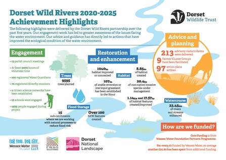
In 2021-22 the Dorset Wild Rivers partnership worked with farmers, landowners and communities across Dorset to deliver enhancements to freshwater environments.
Read the case studies below of a few of the recent and ongoing projects undertaken by the Dorset Wild Rivers partnership
Corfe River
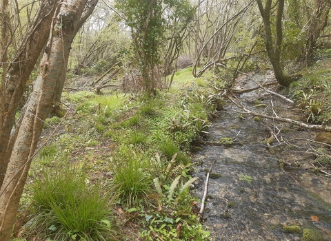
Corfe River is approximately 13.5km from source to sea running through clay soils along the Corfe Valley cutting through the Purbeck chalk ridge and then up through sandier soils to Poole Harbour. The Corfe was given a failure classification by the Water Framework Directive (WFD) for poor levels of macrophytes due to elevated phosphate entering the river from sewage treatment works and land use as well as high flows and sediment loading. Whilst the channel is mostly natural and unmodified, it is heavily shaded by trees. In response to the WFD classification, the Corfe River project started in 2018 supported by the Dorset Catchment Partnership and funded by the Environment Agency. The lead partner is Dorset Wildlife Trust with FWAG South West in a supporting role and the National Trust and farmers as key delivery partners, as well as the parish councils of Arne, Church Knowle and Steeple.
Over the past three years, significant progress has been made:
Fencing and trackwork to exclude livestock from the river, reduce bank erosion and create riparian buffer zones to strip sediment and nutrients from surface water before it enters the river as well as creating a wildlife-rich corridor.
Engagement with the local community, farmer and landowner liaison, stakeholder engagement with parish councils and the National Trust.
Selective coppicing, thinning and crown-raising along a 750m shaded section of the Corfe River to allow light to reach the channel which will be beneficial to wildlife.
Installation of a 25m silt barrier fence to catch surface water run-off which is laden with sediment before it enters the river.
Tree management and planting to enhance the riparian buffer zone and create marginal wetland habitat.
Involvement of our River Champions, community volunteers who help with practical habitat management tasks.
Riverfly workshop to train volunteers to sample, identify and count invertebrate groups, the aquatic stages of mayflies, caddisflies, stoneflies as well as freshwater shrimps in order to help provide a more comprehensive analysis of the river.
Devil's Brook
The primary objectives of the Devil’s Brook project were to work with the local communities to reduce flood risk from surface water flooding, to improve the river for fish and other wildlife and to intercept overland flow pathways to improve water quality in the Devil’s Brook and Cheselbourne Stream.
What has been delivered?
632 metres of riparian fencing on Devil’s Brook and 113 metres on Cheselbourne Stream.
Two hydrological reports.
460 metres of hedge planting and four riparian woodland sites.
A pond created in the School grounds which takes surface water.
Link to Stage Zero research carried out by Environment Agency which has identified two potential floodplain reconnection projects.
Reversion of a 1.5 hectare arable field adjacent to the Cheselbourne Stream to permanent grassland.
A community-produced Riparian Owners Handbook which has been shared with residents of Cheselbourne and Dewlish.
Regular Parish Council updates through the monthly newsletter and an increase in interest from residents in the Devil's Brook.
The Devil's Brook project was funded by the Wessex Water Foundation Partners Programme, Environment Agency Water Environment Improvement Fund and the Tree Council–Network Rail community tree planting initiative. The lead partner was the Farming Wildlife Advisory Group South West with Dorset Wildlife Trust in a supporting role and Cheselbourne Parish Council as a key delivery partner, as well as the Stream Group and Cheselbourne Primary School.
River Asker
The River Asker rises under Eggardon Hill and flows for about 12km until it meets the Rivers Brit and Simene in Bridport. The catchment is mostly agricultural with a mix of arable and dairy farming.The River Asker has been classified as ‘Poor’ by the Environment Agency because there are less fish species and plant species that you would normally expect for this type of river. The main issues which have been identified are artificial barriers in the river, shade from riparian trees, catchment land-use and invasive species. The community has come together to tackle these issues, particularly riparian trees and Himalayan balsam and they have started investigating opportunities to bypass some of the historic weirs along the river as well as establishing a river monitoring group.
In addition, landowners in the catchment have engaged with the project to plant hedgerows and create silt traps on high risk flow pathways, to install natural flood management solutions in the headwaters and trial different herb-rich grass mixes to see what impact they have on water infiltration and fodder quality.
- Over 70 people have been directly engaged with the project, including eight skilled citizen scientists.
- 1.4km of habitat improvements.
- 2km of natural flood management covering the headwaters of the catchment.
- 15ha of improved land management and 400m of new hedges for the benefit of the water environment.
- At least 700 hours of community effort.
This project was delivered by the Dorset Wild Rivers partnership of the Dorset Area of Outstanding Natural Beauty, Dorset Wildlife Trust and the Farming and Wildlife Advisory Group South West with the support of the Dorset Catchment Based Approach, Environment Agency and Wessex Water, and in conjunction with residents of Loders, Uploders and Askerswell.
Riverfly Partnership
Dorset Wildlife Trust runs a River Monitoring Scheme which is based on the counting at regular intervals of key insect populations and other invertebrate groups in rivers across Dorset as a method of assessing river health and water quality. Many insect and invertebrate species are extremely sensitive to pollution levels and therefore their numbers act as an early warning system of any potential problems.
Volunteers are trained as Riverfly monitors using the methodology provided by the national Riverfly Partnership. The volunteers carry out one-hour surveys on a monthly basis between April and September and count the number of eight different groups of river insects and other invertebrates through a 3 minute kick sample. Many of our volunteers carry on outside these months if it is safe to do and also monitor redds (non-migratory trout, and, migratory salmon and trout spawning sites). The data obtained is submitted online to the national database and/or to us at the Dorset Wildlife Trust. in the event of a reduced count, the Environment Agency may be contacted to investigate in the event of a potential pollution incident.
The scheme is of interest to keen anglers and wildlife enthusiasts alike, who both share a concern for the present and future health of our rivers. If you are interested in volunteering, please email Angus Menzies
River Char and Monkton Wyld Stream Community Project
The first phase of the River Char and Monkton Wyld Stream Community Project was a consultation process with businesses, including farmers, statutory bodies,and utility companies to get their views on the state of the river. The findings formed the basis of the State of the River Char and Monkton Wyld Stream report, along with an action plan.
The community project was officially launched on 11 December 2021 at Becklands Farm, Whitchurch Canonicorum and was attended by 45 members of the public. The event started with a brief introduction in the barn followed by a guided walk along the river looking at wildlife and land management issues. Such was the interest, we held another, online, Q&A session attended by 37 members of the public.
A herbal lay workshop for landowners demonstrated the value of managing pastures in a way that is better for soils, making them more robust in the face of climate change, including increased rainfall penetration, leading to less impactful run-off. As a result of this workshop, a site visit was arranged to tenanted land at Mapperton Estate, farmed by Sophie and Tom Gregory to look at herbal lays in action and to hear from them about the benefits realised from adopting this form of management. An online workshop was also held for farmers looking at Maximum Sustainable Output, a concept developed by Nethergill Associates which identifies the best model for operation from an environmental as well as economic point of view. As a result of this workshop, two farms requested more detailed surveys and environmental advice has been given to two other landowners in the river catchment. Volunteer sessions have helped to deliver improvements throughout the catchments restoring 250 metres of river at five locations and planting 220 metres of hedging on flow pathways and the restoration of a pond.
Thanks to Char Valley Parish Council, particularly Councillors Hilary Joyce and Andrew Carey and we are grateful for the support of the Environment Agency, Wessex Water and the National Lottery Heritage Green Recovery Challenge Fund.
Stour Headwaters
The Stour Headwaters project is a five-year partnership project now in its fifth and final year and aims to deliver improvements in the water environment in the Stour catchment, seeking to improve water quality, increase biodiversity and reduce flood risk. FWAG South West (Farming Wildlife Advisory Group) works with farmers within the catchment to slow the flow of water from their land, to reduce flood risk in downstream communities and to reduce the number of nutrients and sediment entering the River Stour and its tributaries. The project is a partnership between many organisations including the Stour Catchment Initiative, Catchment Sensitive Farming (CSF), Dorset Wildlife Trust and Wessex Water.
In 2021-22, the project has engaged with 12 farms in the headwaters to deliver tree planting on four farms along the upper Stour, Lodden and Fern Brook to create new woodland areas and intercept run-off whilst improving riparian habitat connectivity.
In response to the flooding in Motcombe in October 2021, the project has worked closely with a farmer in the Fern Brook to install 10 large woody debris dams were installed and 2.5ha of woodland creation are planned for 2022/23.
On the River Cale, 504m of riparian fencing has been installed to create better habitats and two scrapes have been created to benefit water quality, flood storage and overwintering waders. A historic stream is to be restored on the Lodden following de-culverting and the creation of a new header pond as well as skylighting to allow more sunlight to reach the river bed.
An important part of the project has been engaging with farmers with regard to how agricultural run-off can affect watercourses and the use of strip tillage to reduce the use of cultivations of temporary grassland swards as well as advice on slurry and manure management and the Countryside Stewardship scheme which aims to enable farmers to improve practices.
Thanks to Sean Tyrell from Wessex Water for the infield monitoring on the Lodden, the Environment Agency for continuing to support the project and the Project Board and Technical Group for their guidance.
River Hooke catchment
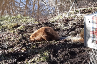
The River Hooke rises from a large number of chalk springs starting at Toller Whelme and is joined by the Toller Brook, the Frogmore stream and Wynford Eagle tributary. It joins the River Frome at Maiden Newton which, downstream of Dorchester, is designated SSSI and lies within the Poole Harbour Catchment. Over the past three years, the Dorset Wild Rivers project has delivered works throughout the catchment including reconnecting and expanding wet woodlands, installing log jams, undertaking fish habitat surveys and delivering the Enclosed Beaver Scientific Study in which a pair of adult beavers have been released into an enclosed site in order to monitor the impact they have on the landscape and the river.
In 2019, the Environment Agency (EA) identified the catchment as a priority for Natural Flood Management (NFM) solutions and have funded several project phases including a fluvial audit and sediment survey as well as bespoke farm action plans.
The work within the Hooke catchment this year has essentially been a culmination of the last three years of project development, catchment planning and farmer engagement leading to the delivery of NFM measures and baseline monitoring. The measures being implemented aim to tackle sediment and water quality issues (which are arising from poor livestock and nutrient management) and localized surface water flooding. In doing so, habitat connectivity will be improved as well as building resilience to climate change through additional flood storage.
The benefits of the work on the Hooke will reach the River Frome as well as Poole Harbour, therefore complementing schemes such as the Poole Harbour Nutrient Management Scheme and Wessex Water’s subsidiary EnTrade, both of which operate to address nutrient reductions and broader catchment management respectively.
The National Trust is a significant landowner within the Corfe River catchment and we strongly endorse the Dorset Wild Rivers project's catchment-wide approach with a particular focus on improving water quality and biodiversity through the restoration of natural catchment processes and diversification of stream morphology and building up support among the local community for longer term change.National Trust Purbeck Office
Our Partners
Dorset Wild Rivers is a partnership between Dorset Wildlife Trust, Farming and Wildlife Advisory Group South West, Dorset Area of Outstanding Natural Beauty, Dorset Catchment Partnership and the Environment Agency funded through the Wessex Water Foundation Partners Programme Phase 6.